


Environmental Projects
Gloucester County – From Boundary Lines to Wetland Lines
DPK Consulting Supports – Remedial Action Planning at Active Industrial Facility in Carteret, NJ
Are Your Customer’s DPCC Plan Deadlines Coming Soon?
DPK Knows Environmental Easement Survey
DPK helps Environmental Consultants
Overcoming Challenges to Advance
Selected Project
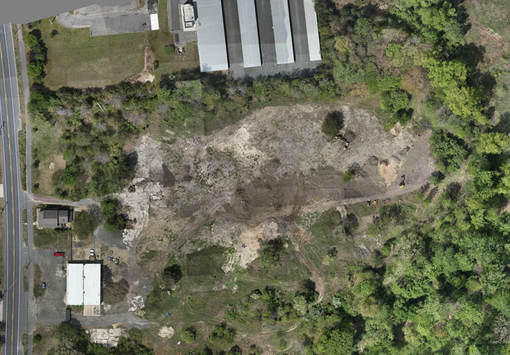
DPK Consulting Integrates Boundary Surveying, UAS/LiDAR Technology and Environmental Support for this Gloucester County Property.
Comprehensive survey deliverables provided the foundation for wetland permitting and future project planning.
Project Overview
When a customer required detailed property information to support environmental objectives at a site in Gloucester County, New Jersey, DPK Consulting delivered a comprehensive suite of survey services designed to provide a complete understanding of existing site conditions.
Combining traditional boundary surveying with aerial LiDAR technology and wetlands mapping support, DPK assembled the information necessary to support the environmental review process and future planning efforts.
A Multi-Discipline Approach
Working from documents supplied by the customer, DPK performed supplemental deed research and prepared a Boundary Survey to establish the property limits and identify any discrepancies requiring further consideration.
To provide a detailed representation of existing site conditions, aerial photography with LiDAR was utilized to develop topography throughout the property. The aerial mapping was combined with the boundary survey to depict on-site features as well as adjoining features within ten feet of the property limits. Topography was developed with one-foot contours.
DPK also provided wetlands survey support in accordance with NJDEP Freshwater Wetlands Letter of Interpretation requirements. Approximately thirty-eight wetland flags, previously delineated by others, were located and incorporated into the survey. Numbered wetland line segments, photo identification locations and soil sample locations were included to support the permitting process.
Bringing Information Together
Projects involving environmental permitting often require information from multiple disciplines. By integrating boundary surveying, aerial LiDAR topography and wetlands mapping into a coordinated deliverable, DPK provided the customer with a comprehensive background document to support environmental objectives and agency review.
Results
The completed survey package provided the information necessary to support wetlands permitting requirements while establishing a reliable foundation for future project planning.
Better Information for Better Environmental Decisions
Whether supporting environmental permitting, land development or engineering projects, DPK Consulting combines traditional surveying expertise with advanced geospatial technologies to provide accurate, dependable information from the ground up.
Put DPK Consulting on your preferred contractors list and contact our team to discuss your next project.
Call 732-764-0100 and ask for Ray Hyman, or James Heiser. Or below, utilize our convenient 24/7 Quick Quote page to upload your SOW and site docs. A DPK project manager will respond promptly. Get your quote started today!
DPK Consulting Integrates Boundary Surveying, UAS/LiDAR Technology and Environmental Support for this Gloucester County Property.
Comprehensive survey deliverables provided the foundation for wetland permitting and future project planning.
Project Overview
When a customer required detailed property information to support environmental objectives at a site in Gloucester County, New Jersey, DPK Consulting delivered a comprehensive suite of survey services designed to provide a complete understanding of existing site conditions.
Combining traditional boundary surveying with aerial LiDAR technology and wetlands mapping support, DPK assembled the information necessary to support the environmental review process and future planning efforts.
A Multi-Discipline Approach
Working from documents supplied by the customer, DPK performed supplemental deed research and prepared a Boundary Survey to establish the property limits and identify any discrepancies requiring further consideration.
To provide a detailed representation of existing site conditions, aerial photography with LiDAR was utilized to develop topography throughout the property. The aerial mapping was combined with the boundary survey to depict on-site features as well as adjoining features within ten feet of the property limits. Topography was developed with one-foot contours.
DPK also provided wetlands survey support in accordance with NJDEP Freshwater Wetlands Letter of Interpretation requirements. Approximately thirty-eight wetland flags, previously delineated by others, were located and incorporated into the survey. Numbered wetland line segments, photo identification locations and soil sample locations were included to support the permitting process.
Bringing Information Together
Projects involving environmental permitting often require information from multiple disciplines. By integrating boundary surveying, aerial LiDAR topography and wetlands mapping into a coordinated deliverable, DPK provided the customer with a comprehensive background document to support environmental objectives and agency review.
Results
The completed survey package provided the information necessary to support wetlands permitting requirements while establishing a reliable foundation for future project planning.
Better Information for Better Environmental Decisions
Whether supporting environmental permitting, land development or engineering projects, DPK Consulting combines traditional surveying expertise with advanced geospatial technologies to provide accurate, dependable information from the ground up.
Put DPK Consulting on your preferred contractors list and contact our team to discuss your next project.
Call 732-764-0100 and ask for Ray Hyman, or James Heiser. Or below, utilize our convenient 24/7 Quick Quote page to upload your SOW and site docs. A DPK project manager will respond promptly. Get your quote started today!
Try Our 24/7 RFP Solution. Get Your Project Bid Fast!
DPK has developed this simple, 2-step Quick Quote system to streamline your project request and accelerate our response. This form enables you to securely submit your project details, select the specific services you require, upload supporting files, and provide key information needed for a prompt and accurate proposal.
We appreciate the opportunity to support your project. Our high touch communication and multi-service expertise is what defines DPK Consulting. Thank you.
Need Help?
Need something more? Call 732-764-0100 and ask for Ray Hyman.
DPK Quick Quote Form
"*" indicates required fields