


Commercial Projects
Existing Properties. New Possibilities.
Three Project Phases. Three Different Customers. One Surveying Partner.
ALTA Survey Supports Confidence in Commercial Property Transaction
DPK Consulting Helps Bring New Topgolf Facility to Life in Parsippany, New Jersey
DPK Consulting Delivers Comprehensive ALTA Survey to Support a Central New Jersey Power Plant
Great Projects Start with a Strong Foundation
DPK Consulting Supports Multi-Phase Construction Project
Manhattan – Rooftop ALTA Survey
South Jersey Commercial
Manhattan Historic Church
Brooklyn 11 Story Building
Hoboken Watermain Replacement
PA ALTA Surveys
Utilities NY Story
Palmyra
Hazelton, PA
Selected Project
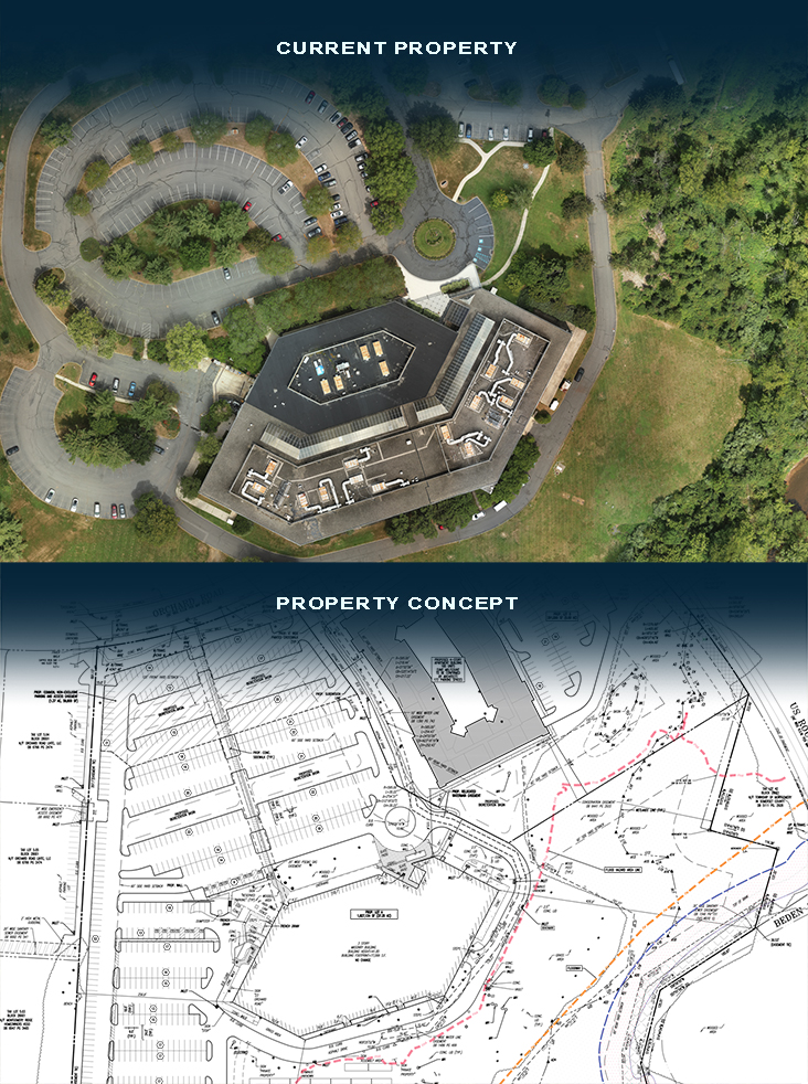
Existing Properties. New Possibilities.
DPK Consulting integrates boundary, aerial LiDAR, utility, wetlands, and tree surveying to support the evaluation of a large commercial property’s redevelopment potential.
As commercial real estate needs evolve, property owners and developers are increasingly exploring opportunities to reposition existing properties for new uses. Changes in demand for traditional office and warehouse space, coupled with continued interest in residential and mixed-use development, are encouraging a closer look at properties that may offer opportunities for subdivision and redevelopment.
These opportunities, however, require a thorough understanding of existing property conditions, environmental constraints, and regulatory considerations before development plans can advance.
DPK Consulting was engaged to provide comprehensive surveying services for a large commercial property being evaluated for subdivision and potential redevelopment. The assignment required an integrated approach to documenting property boundaries, topography, existing infrastructure, and environmental features that could influence future development decisions.
Understanding the Opportunities and Constraints
Redeveloping previously developed properties can offer advantages over expanding into undeveloped areas, particularly where existing infrastructure may be incorporated into future plans.
However, redevelopment is not without challenges. Stormwater management requirements, environmental regulations, wetlands, and flood hazard considerations can significantly influence how a property may be subdivided or developed.
For this project, the presence of wetlands and a brook introduced important considerations related to potential flood hazards and development constraints.
DPK’s surveying assignment brought together five complementary services to provide the detailed site information needed by the project team.
Five Integrated Surveying Services
Boundary Survey
DPK’s boundary surveying scope included property record research, deed analysis, and review of available title information to establish and document property boundaries and relevant adjoining conditions.
Aerial Topography with LiDAR
Given the property’s size, DPK utilized aerial photogrammetry and LiDAR technology to collect detailed site information. The scope included one-foot topographic contours, existing site features, adjoining conditions, and approximately 2,500 linear feet of brook bank mapping.
This aerial approach provided an efficient means of collecting comprehensive elevation and terrain information across a large property.
Utility Survey
DPK’s scope included documenting observable above-ground utility features and available surface evidence of infrastructure, including relevant stormwater and sanitary sewer information.
Wetlands Survey
Working from wetlands delineation flags established by others, DPK was tasked with locating up to 30 wetland points and incorporating them into the property’s survey documentation.
Tree Survey
DPK’s assignment also included locating existing trees measuring six inches or greater in caliper outside the designated 22.5-acre wooded area, providing additional information about existing site conditions.
Accurate Site Information Supports Smarter Redevelopment
The value of comprehensive surveying extends beyond documenting a property’s existing conditions. For owners and developers considering subdivision or redevelopment, accurate information about boundaries, elevations, infrastructure, wetlands, and other site features is essential to evaluating opportunities and understanding potential constraints.
By integrating traditional surveying with advanced aerial LiDAR technology and environmental feature documentation, DPK provided a coordinated approach to collecting the information needed to support informed redevelopment planning.
Beyond the deliverables shared about this exciting project, DPK stands ready to support their customer as they move towards their ultimate goals
As commercial real estate continues to evolve, DPK Consulting helps property owners, developers, engineers, and environmental professionals better understand the opportunities and challenges associated with existing properties.
DPK Consulting, Service Without Boundaries.
Try Our 24/7 RFP Solution. Get Your Project Bid Fast!
DPK has developed this simple, 2-step Quick Quote system to streamline your project request and accelerate our response. This form enables you to securely submit your project details, select the specific services you require, upload supporting files, and provide key information needed for a prompt and accurate proposal.
We appreciate the opportunity to support your project. Our high touch communication and multi-service expertise is what defines DPK Consulting. Thank you.
Need Help?
Need something more? Call 732-764-0100 and ask for Ray Hyman.
DPK Quick Quote Form
"*" indicates required fields