


Commercial Projects
Existing Properties. New Possibilities.
Three Project Phases. Three Different Customers. One Surveying Partner.
ALTA Survey Supports Confidence in Commercial Property Transaction
DPK Consulting Helps Bring New Topgolf Facility to Life in Parsippany, New Jersey
DPK Consulting Delivers Comprehensive ALTA Survey to Support a Central New Jersey Power Plant
Great Projects Start with a Strong Foundation
DPK Consulting Supports Multi-Phase Construction Project
Manhattan – Rooftop ALTA Survey
South Jersey Commercial
Manhattan Historic Church
Brooklyn 11 Story Building
Hoboken Watermain Replacement
PA ALTA Surveys
Utilities NY Story
Palmyra
Hazelton, PA
Selected Project
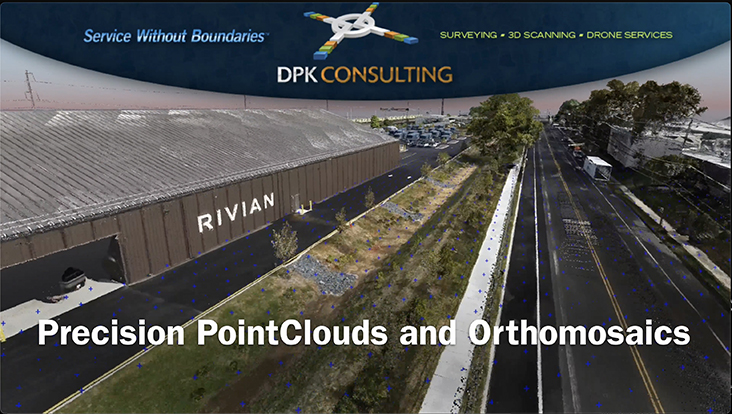
From environmental remediation to commercial development and final as-built documentation, DPK Consulting supports the transformation of a New Jersey property into a RIVIAN automotive dealership.
Successful commercial redevelopment requires the expertise of multiple professional disciplines, often involving different project teams with distinct responsibilities at each stage. Environmental consultants, civil engineers, developers, and property owners all depend on accurate surveying and geospatial information to advance their objectives.
What if one surveying partner could support them all?
DPK Consulting’s involvement in the development of a RIVIAN automotive dealership demonstrates the value of comprehensive surveying capabilities throughout a property’s transformation.
From the site’s initial environmental remediation through commercial development and final documentation of completed construction, DPK provided surveying support across three distinct project phases, serving three different customer groups.
One Property. Three Phases.
Phase 1: Environmental Remediation Support
Before commercial development could proceed, the property required remediation of existing environmental impacts. DPK supported their environmental consulting firm customer by surveying the property’s monitoring wells and preparing NJDEP Form B’s.
Phase 2: Civil Engineering and Commercial Development
Following remediation, the property moved into commercial development. DPK continued its involvement, this time supporting the engineering firm responsible for advancing the site’s development. The transition from environmental remediation to commercial construction demonstrates the advantage of a surveying partner with the expertise to serve different technical disciplines as a project evolves.
Prior to the final phase, DPK provided an ALTA survey needed to support the property’s purchaser and lender.
Phase 3: Final As-Built Documentation
With construction completed, DPK’s role transitioned once again, providing the property owner with a final as-built survey documenting the finished property’s existing conditions.
DPK illustrated their ability to maintain consistency, continuity and quality throughout the project. From the earliest tasks to the final deliverable, DPK remained a surveying resource throughout the property’s development for nearly a decade.
The ability to capture accurate site data for 3 distinct land development applications is the key part of this project story. Secondarily, DPK’s ability to capture and transform high tech geospatial information into multiple feature extractions serves a broad range of professional needs.
As demonstrated in the accompanying video, DPK’s advanced Unmanned Aircraft Systems (UAS) capabilities add another dimension to its comprehensive surveying services. Aerial LiDAR and photogrammetry data can be processed into a variety of detailed geospatial deliverables, each serving different project requirements.
These include:
- High-resolution point clouds for detailed three-dimensional representations of site conditions.
- Orthomosaics for accurate, comprehensive aerial mapping.
- Terrain extraction and digital terrain models for evaluating ground surfaces and site characteristics.
- Triangulated Irregular Network (TIN) models for representing terrain geometry and elevation changes.
- Contour mapping for visualizing site elevations and topographic features.
- Point cloud classification for distinguishing ground surfaces, vegetation, structures, and other features.
The ability to extract multiple types of information from a single flight gives environmental professionals, engineers, developers, and property owners access to versatile geospatial resources tailored to their needs.
The video illustrates DPK’s broader UAS data-processing capabilities; not every featured deliverable was necessarily part of the RIVIAN project scope.
Comprehensive Capabilities. Continuity Across the Project Lifecycle.
The RIVIAN dealership project demonstrates the advantages of working with a surveying company whose capabilities extend across multiple industry segments and project stages. DPK Consulting has the professional expertise, surveying technologies, and breadth of services to support all three.
DPK Consulting, Service Without Boundaries.
Try Our 24/7 RFP Solution. Get Your Project Bid Fast!
DPK has developed this simple, 2-step Quick Quote system to streamline your project request and accelerate our response. This form enables you to securely submit your project details, select the specific services you require, upload supporting files, and provide key information needed for a prompt and accurate proposal.
We appreciate the opportunity to support your project. Our high touch communication and multi-service expertise is what defines DPK Consulting. Thank you.
Need Help?
Need something more? Call 732-764-0100 and ask for Ray Hyman.
DPK Quick Quote Form
"*" indicates required fields