

The applications of drone-based services continue to grow in all areas of land development, restoration, and preservation. For nearly 20 years, DPK Consulting has been recognized by customers for their quality and accuracy in the environmental, engineering and construction industries. Fast forward to today, and they are demonstrating week in and week out how the latest land surveying technology is changing the paradigm for how this important work is getting done.
PROJECT OVERVIEW
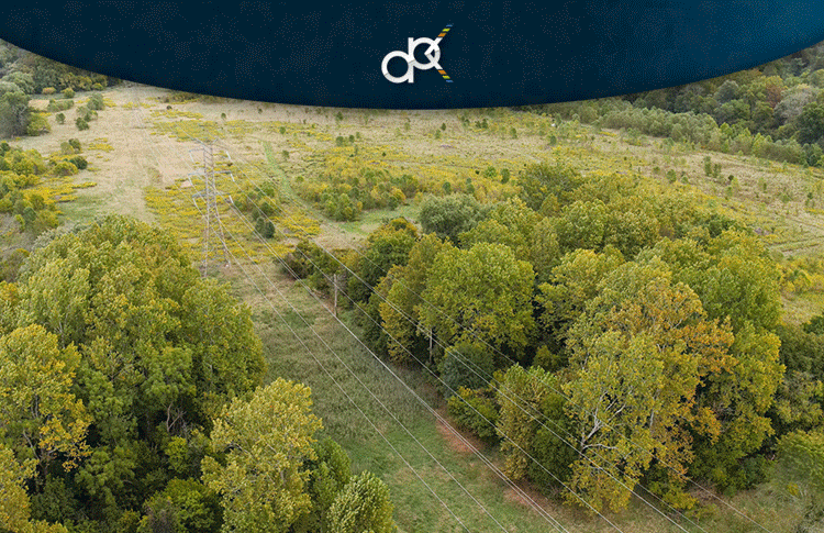
John Jengo is a Professional Geologist in several states, a Licensed Site Remediation Professional in New Jersey, and a Principal Hydrogeologist at Stantec, a leading environmental consulting firm. He is the lead consultant on this project – a large-scale reforestation of former agricultural fields at Duke Farms, located in Hillsborough Township, Somerset County, NJ.
The project is being funded by a Fortune 50 company as compensation for the historical loss of wetland and forest habitat several miles away. According to Mr. Jengo, the short-term goal is to replace thousands of harmful invasive plant species with approximately 53,500 native plants on this roughly 112-acre site. The long-term goal is to create valuable ecological habitat, increase biodiversity, and enhance flood resiliency in this region along the Raritan River.
OVERCOMING OBSTACLES
All wetland and reforestation restoration projects come with obstacles to success, including availability of native plants that can be acquired, competition from invasive species that often overwhelm planted native species, variability of weather conditions after the planting that can damage and destroy the desired plantings (e.g., floods, drought), and insect infestations and whitetail deer over browsing that can decimate the desired plantings.
Wetland and reforestation restorations are considered one of the most challenging ecological projects that can be implemented and there are limited ways to reduce the risk of failure. There are also inherent challenges to assessing the existing conditions, which in this case were successfully mitigated by DPK’s experience and leading survey technology.
SOLUTIONS
“There was no better way to assess the present-day coverage of invasive species in these former agricultural fields than DPK’s drone flyover,” states Mr. Jengo. “They created orthomosaic maps that I could ground truth to ascertain which acreage was covered by certain undesirable plants. Their data enabled me to quantify the level of effort to conduct invasive species treatment and/or removal in specific areas so that I could develop an accurate scope of work for landscaping contractors to prepare the fields for planting. To have attempted to accomplish this invasive plant mapping via a ground surface survey would have taken weeks and would not have been as effective. A second effort by DPK to map the topography via LiDAR,” adds Mr. Jengo, “has enabled me to design a planting scheme based on the microtopography of the fields (water-loving plants in the lower areas, plants that can tolerate somewhat drier conditions in the higher areas).”
CONCLUSION
The initial phase of this reforestation restoration project has been very successful. According to DPK Consulting’s President and CEO James Heiser, the value of DPK’s services will continue to support this ongoing project. “Our aerial solutions will help Stantec and John monitor this site to ensure that it’s advancing in the right direction. It will also enable them to provide their client and governing entities with the necessary evidence that the restoration is in fact developing on the timeframe required. We’re proud to be a part of this and look forward to contributing to this important environmental asset,” concludes Mr. Heiser.